MappyField 365 For Dynamics 365
Dynamics 365 Map: Expand your business with location intelligence
Mappyfield 365 is a powerful geo mapping plugin within Dynamics 365 to boost your business productivity and scale it geographically. Explore power features like visualizing CRM data on map, Live Tracking, Auto Scheduling, Proximity Search, Auto check-ins, Follow Ups, Territory Management, Heat Maps, Dashboards, and more.

Our Customers


Experience MappyField 365: Visualize. Plan. Monitor. Succeed.
Mappyfield for Dynamics 365 can be a game changer for businesses for whom location intelligence is the heart for scaling their reach in the modern era. Mappyfield 365 can especially help businesses with:
- Data loading speed for huge data
- Productivity enhancer automation tools
- Better deals, support, customer service
- Seamless, intuitive & interactive UI
- Connect instantly with onfield team via Live Chat
Accelerate your Business With Mappyfield 365 + Dynamics CRM
Your field business needs next-generation productivity tools to manage multiple aspects of your business. Mappyfield is the right choice for you.

-

Live Chat for Instant Connectivity Exclusive
Bridge the gap between onfield teams and managers with Live Chat. Instantly connect with onfield team for quick decision-making and sharing valuable insights.

Import and Plot External Data (CSV) (Upcoming)
Import external data from a CSV file into the map and plot it. Also, import the data into Dynamics CRM.
-

Build More Pipelines and Drive Revenue
With custom territory management and proximity search, build segmented pipelines for your marketing, sales, or field service teams.

Plot Related Records (Upcoming)
Plot and view an individual entity's details and related records on the map.
-

Appointments Automation
Automate visit scheduling of reps with Direct Appointment Booking, Proximity based Auto Check-ins, Meeting Notes, and activity planning seamlessly!

Create Activity While Saving and Updating a Route (Upcoming)
Add an activity like "appointment" when saving or updating a route in Dynamics 365 Map.
-

Data Visualization on Maps
Visualize, Filter, and Geocode your CRM Data on Maps and create heatmaps with a lot of different junction possibilities for easy and better business decisions.

Smart Routing: Save Time & Materials
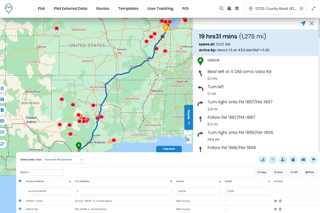
Create, optimize, manage and share routes for field reps, watch their progress and locations through map. Save more with less fuel and time consumption!
Request Personalize Demo
Make your on-field and off-field teams more productive
Be it creating productive routes for reps or completing all the appointments without missing any, Mappyfield 365 can serve these better!
-
Sales Teams
Equip your field sales team with better tools, reduce their operational overheads and allow them to focus more on conversions.
-
Marketing Teams
With Mappyfield, your marketing team can plan niche campaigns with localizations and generate fruitful pipelines for sales teams.
-
Field Service Teams
Extend your door-to-door services, be it cleaning, repairing, collections, and deliveries, more effectively with Mappyfield 365.

-
Delivery Teams
Enable your delivery team with optimized routes of delivery, reduce order-to-delivery turnaround and serve customers faster!
-
Managers from Office
Enable your managerial level to visualize operations progress, make better decisions with analytics, and monitor teams effectively.
-
Partners, Suppliers & Distributors
Make your distribution channels faster by identifying nearby suppliers and partners within the territories to grow your business.
Mappyfield 365 and Industries

RealEstate

Healthcare & Pharma

Professional Services

Manufacturing
Scheduling and Tracking
Mobile App for Field Reps
MappyField has a fully functional mobile version. Employee's work and transit hours are noted (Proof of Work). Boost productivity by reducing time wasted in understanding location.
Live Tracking
With live location tracking, managers can know if executives were actually where they say they were at specific times. Eliminate scope of miscommunication or time theft.
Visit Planner
Managers can design daily schedules of their on-field teams to assign each agent with client details and a route that shows the sequence of meeting clients.
Automatic Check-In and Check-Out
Auto check-in and check-out when sales reps enter and leave the radius of the client locations, respectively.
Optimized Route Plotting
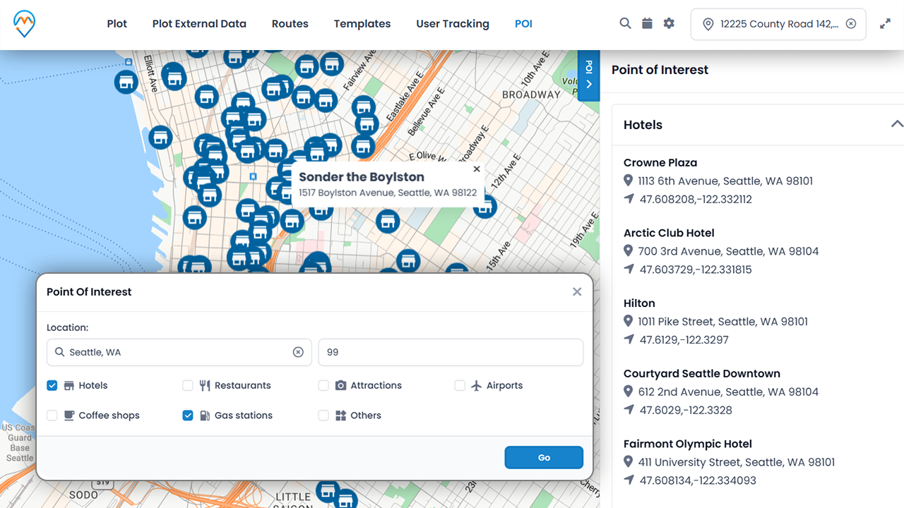
Point of Interest (POI)
Find restaurants, cafes, banquets, medical stores, gas stations, etc., along the way to save time and fuel consumption.
Open Route in Google or Apple Maps
Sales reps can access the route links using Google Maps or Apple Maps to view the route designed by managers.
Share Route via Email
Send optimized routes to sales reps over email that connects all client locations. Sales reps can use these links to find the shortest route on Maps.
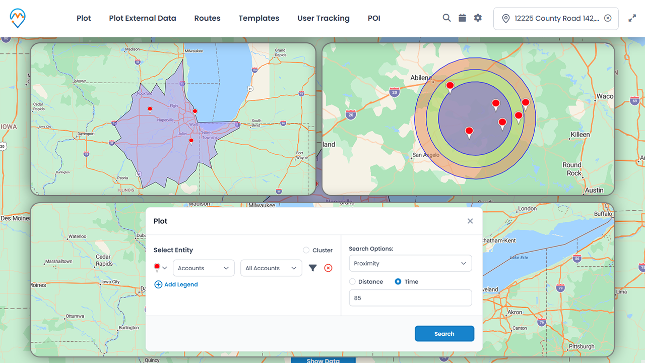
Proximity Search
Through Location
Search client locations around your current location for a quick view of customers in nearby proximity.
With Distance
Add upto three proximity levels to find nearby records based on added proximity (based on Kilometers and Miles).
By Time
Find clients in your proximity by using time as a filter to see how many clients are nearby.
Sales Pipeline
Territory Management
Improve visualization of records, assign sales reps, prioritize and manage a group of customers and prospects, who are typically organized by segments such as geography, industry, etc.
Heat Maps
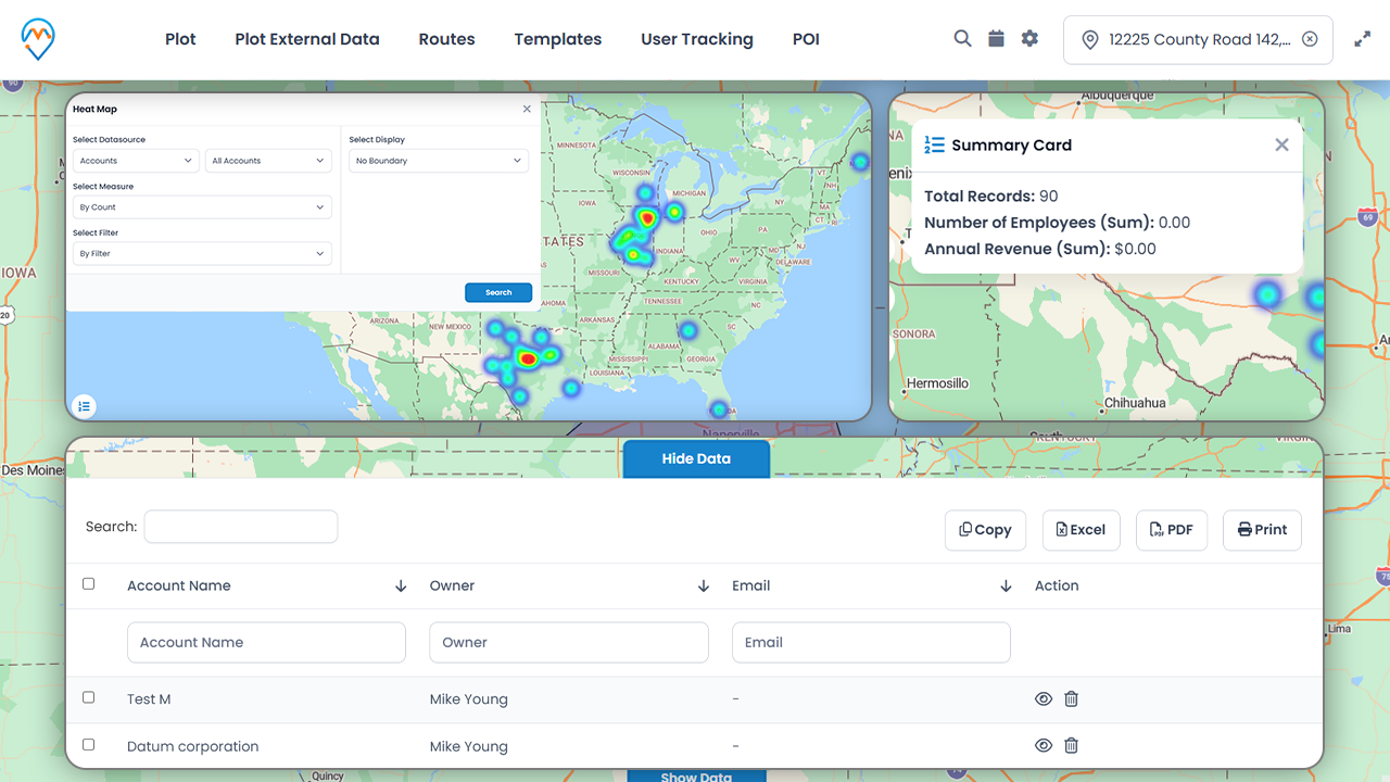
Visualize entities based on region (city, state, country) or choose no boundary where different colors are used based on the density of records.
Geo-Analytical Dashboards
Choose from multiple dashboards to refine marketing strategy, analyze risks, improve customer experience, monitor business performance, and more.

Map CRM Data with ….
Filters like Region, Drawing, Territory, or by User
View data on the desired proportion of the map by using different filters like region, drawings, territory, or user.
DataGrid and Summary Card
Access all the records from the map screen with the data grid. Get summarized statistical information on the records in the given area.
Geocode any Record(s)
Geocode all the records in bulk or automate the process to save time.
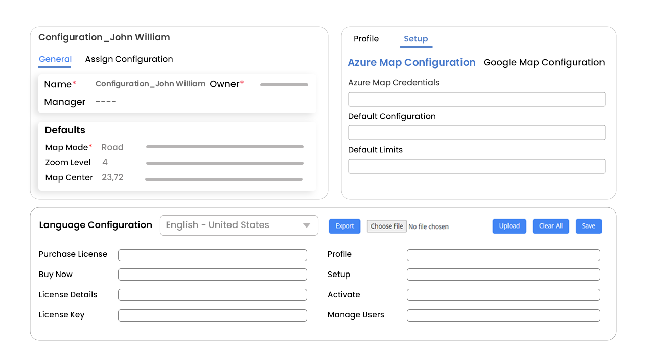
Configurations
Global & User Level Configurations
Define global configurations for all the resources as well as allow user-level configuration to satisfy different requirements.
Security Templates
Give access to configure quick actions like change owner, create new activity, delete records, etc., and filters like by region, drawing, territory, proximity, user/team on the map at the user level.
Multi-Language
View MappyField in your preferred language to make the best use of it.
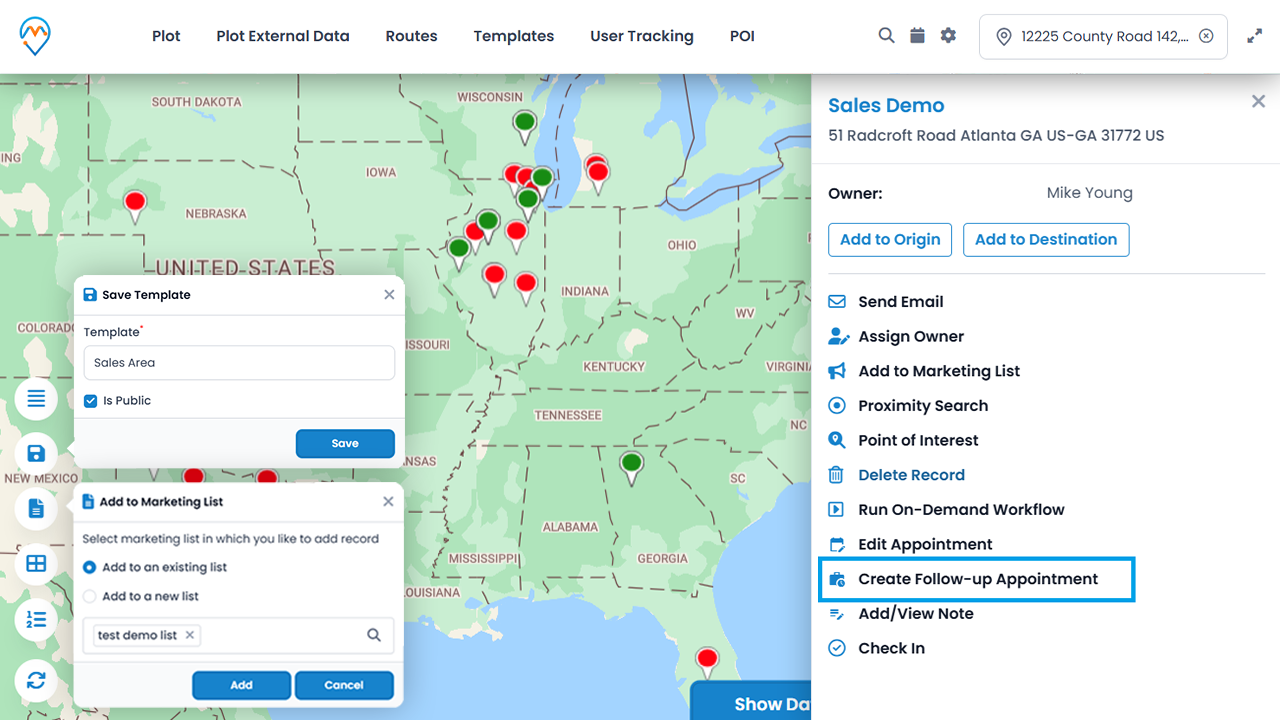
Quick Actions Directly From the Map
Follow-Up Activities
Define the next course of action items, add follow-up appointments, tasks, and more within the map interface.
Add to Marketing List
Quickly add records to your current marketing list or create one right there.
Save your preferences
Save frequently used filters to avoid entering details every time you want to see the desired records.
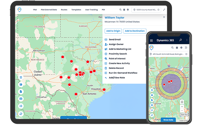
Mappyfield and its compatibilities
Any Device, Any Language
Mappyfield 365, our Dynamics 365 map solution, is fully compatible with multiple languages and devices, from mobile to large desktops.
Dynamics CRM and its versions
The plugin is compatible with Microsoft Dynamics CRM Online (V9.0 and Above)and Powerapps.
Support with Dataverse
Mappyfield is compatible with PowerApps and Dataverse.
Points to Note
- AppJetty License authentication is required for our product MappyField 365 from configuration from web access.
- Supports Azure Map extensively and Google Maps for plotting, routing, and geocoding.
- The user needs to generate the Azure Map API Key from https://www.appjetty.com/blog/generate-azure-map-key/
- Pop-ups should not be blocked in a web browser.
- Microsoft Dynamics 365 CRM(V9.0 and Above) and PowerApps/Dataverse
- Responsive (Mobile Browser Support)
- App Support (Unified User Interface) is available for Dynamics 365.
- When you buy our product, you get only two environments (Production and Sandbox). For additional environments or domains, please contact sales@appjetty.com..
Documents & FAQs
MappyField 365: Installation Configuration
Explore how to install and configure the MappyField 365 plugin.
MappyField 365: Map View Functionalities
Learn how to make the best use of the MappyField 365 functionalities.
Find your answers on our YouTube Channel
General FAQs
What versions of Dynamics CRM does the plugin support?
The plugin is compatible with Microsoft Dynamics CRM and Powerapps.
Can you customize the plugin as per my requirement?
Definitely. You can share your customization request at support@appjetty.com .
Do you provide demo?
Yes, we do. You can view the demo by clicking on "Request Demo".
Do you have a refund policy?
Yes. You can refer to our refund policy by clicking on the following URL
refund policy.
Is the plugin supported on all browsers?
This plugin provides support for Edge (v12 and above), Firefox (v29 and above), Chrome (v33 and above), Safari (v7.1 and above) and Opera (v20 and above).
How to install an AppJetty product from Microsoft AppSource and activate the license steps?
Get the complete step-by-step guide by clicking here for in-depth insights.

Technical FAQs
Does it provide the facility to get geocode(latitude and longitude) from the address?
Yes, you need to click on 'Get Geocode' button in particular records.
Who can set default configuration settings?
Only System Administrator can set default configuration settings.
Can I view entity records based on their views from the MappyField?
Yes, you can view all the records as per their view.
Does it provide a way to generate geocode automatically for new records of a particular entity?
Yes, it does. You need to mark the checkbox in Entity To Map dialog box.
Does it provide a way to generate geocode for all records?
Yes, it does. You can set cron and days. Cron will run and generate geocode for all mapped entities.
Is the plugin supported for PowerApps(CDS)?
Yes, Our Plugin is supported for PowerApps(CDS).
Can I as a Sales Manager schedule my team's weekly or monthly schedule?
Yes, you can do the same with the help of your Autoschedule feature. You can checkout this Blog to understand the functionality of the same.
Can I track my on-field team?
Yes, we have just added the feature of live tracking that allows you to live track your resources, their activities, and their location history.
Does Mappyfield support custom fields created to store the address in the CRM entity?
Yes, Mappyfield 365 supports custom fields created to store addresses in the CRM. The created address fields should be a single line of text fields.
Is there a cap on how many points of interest (POIs) I can retrieve using Azure Maps?
Yes, there’s a cap on the number of POIs that you can retrieve! With a basic key, you can search for POIs up to 100 times. However, you get unlimited POI queries if you have an Enterprise key.
What is the geocoding process in MappyField 365?
MappyField 365 operates using the same geocoding methodology as Azure Maps, relying on its algorithms and data sources to convert addresses and locations into map coordinates. Simply put, all geocodes are obtained from Azure Maps.
Note: If Google Maps is set up for geocoding, the same applies to Google Maps.
Awesome application allowing both sales representatives and sales managers to have an overview of the different sectors they manage. User-friendly configuration panel and easy to use as mapping tool. At last not the least, a competent and helpful support team and developers quick to answer.
Simply we love using it. Being able to add details right from the map is amazing! Increased efficiency.
It is so useful to get location-based data! It is a great addon to an already great CRM. Know everything happening in the space of Themes, Extensions, Apps and Plugins. Explore our knowledge verticals in the domain of Magento, Odoo, WordPress, Dynamics CRM, Sugar CRM, SuiteCRM and Mobile Apps development. We also provide custom developed apps, plugins, extensions and themes. Give us a brief and we'll take care of the rest!What Our Clients Say About Our Work
Cindy KOST
Great mapping, route and sector overview app
Alene
Best app!
Aria white
Very useful and helpful
Knowledge Bank

Didn't find what you were looking for?
Change Log
Version 7.1 : July 23, 2024
Version 6.2 : February 15, 2022
Version 6.1 : December 7, 2021
Version 6.0.0 : May 19, 2021
Version 5.0 : October 28, 2020
Version 4.2.1 : March 19, 2020
Version 4.2 : February 19, 2020
Version 4.1 : January 20, 2020
Version 4.0 : October 10, 2019
Version 3.1 : April 26, 2019
Version 3.0 : January 30, 2019
Version 2.2 : November 27, 2018
Version 2.1 : August 02, 2018
Version: 2.0 : May 02, 2018
Version 1.0 : February 23, 2018


